The most popular Trek route in the world with unparalleled views of the highest peaks on earth – Everest base camp is a dream destination for every mountain lover. Hiking among the Himalayas is not a walk in the park. Harsh terrains with extreme climatic conditions demands very high physical fitness along with great mental strength. Nonetheless thousands of hikers complete Everest base camp trek every year. Astounding peaks, warm tea houses and international standards make this trek one of t a lifetime journey. Soak yourself in the Nepali culture with spectacular views of Mt Everest, Mt Amadablam, Mt Nuptse, Mt Lhotse, Island peak, Lubuche peak and many more
Experienced hikers
5600m (18370ft)
15 days
Min 4 Max 20
16yr to 55yr
Our journey in Nepal begins today. Our trek representative will be waiting for us at the airport. He/she will then drop us off at our hotel where we can take a rest. In the evening we can enjoy a welcome dinner hosted by our team. During the dinner we can enjoy Nepalese cuisine which will introduce us to the country’s fo
Early morning transfer to Tribhuvan Domestic Airport for 30-40 minutes scenic mountain flight from Kathmandu (TIA) to Lukla (Tenzing-Hillary airport),the gateway to the Himalayas. Lukla airport is the highest airport in Nepal and also one of the most dangerous airstrips in the world with just a single runway over a cliff. The journey to the Himalayas begins after registering for a TIMS card at Lukla Tourism Checkpoint. The trail then formally commences entering through Pasang Lhamu Sherpa Memorial gate. As the trail drops down to Thalsaroa and Cheplung, the spectacular vista of surging Dudhkoshi river roar at the trekkers to accomplish the journey. From Cheplung, the trail crosses through suspension bridge over Thado Khola and offers the introductory mountain view of Mt Khumbila (5,761m) before reaching Ghat. The trail continues to the first stop of the trek Phakding offering spectacular demonstration of the prayer wheels, mantras painted Mani stones and gompas. It takes about 1-2 hours of inclined walk to reach the village Phakding.
Flight Duration: 45min
Trek Distance: 6.2km/3.8miles
Trek Duration: 3 hrs
Highest Altitude: 2,610m/8,562ft
After warm breakfast, our second day trekking commences from Phakding. The trail from Phakding leads to various Sherpa villages: Rimijung, Benkar and Chhamuwa which offers serene beauty in the Himalayan region. Climb through the magnificent forest of rhododendron, fir and Mongolia trees until you arrive at the boarder of Sagarmatha National Park at Monjo village. Submit your TIMS card and National park entry card before you move ahead. From Monjo, the trial advances through Tenzing-Hillary suspension bridge over Dudh-Koshi river in Jhorsale village which is the confluence of Dudh-Koshi and Bhote-Koshi rivers. The trek concludes at Namche, the largest tourist hub in Everest region. Namche has all the amenities to spend the night at fully accommodated hotel.
Trek Distance: 7.4 km/4.6 miles
Trek Duration: 5-6 hrs
Highest Altitude: 3440 m/11,285ft
The day at Namche will be the day for exploration and acclimatization. Health expertise suggests acclimation is necessary in Everest region trek to avoid Acute Mountain Sickness (AMS). On this day, the guides arrange short trek from Namche to other Sherpa settlements in the Khumjung valley. The short trip heads towards the Everest view hotel, one of the world’s highest hotels in the world for tea break and also for panoramic view of Mt. Khumbila (5,761m), Mt. Thamserku (6,623m), Mt. Everest (8,848m), Lhotse (8,516m) and Ama Dablam (6,812m). The trail then climbs uphill to Khumjung and Knude village with the physically fit trekkers. The trekkers with weak physical fitness can return to the lodge at Namche. The main climax of the trip is to visit Khumjung Gompa and Khumjung Hillary school which was established by Sir Edmund Hillary in 1961. After inspecting Khumjung Gompa and school, drop down to another Sherpa village, Kunde which is renowned for ‘Hillary hospital’: the largest hospital of Khumjung region established in 1966.
Time taken: 6 hours, 8-10 km
Water sources: You can refill your water bottles at tea houses on the way.
The trek from Namche to Phortse Thanga. Mt Everest peeks at you from behind the mountains in the distance. PC: Christopher Immanuel
The trail climbs out of Namche and descends to Khumjung village. Khumjung is a Sherpa village with 40-50 houses. From Khumjung, the trail climbs up the stairs and hugs the sides of the mountain. It diverges from the main Everest highway at Sanasa, after Khumjung. Up to Sanasa, you will be trekking through forests, after which you reach a village.
You’ll be able to see Tengboche monastery from here. It is said that Tenzing Norgay spotted this monastery from the summit of Everest. The trail then climbs to Mong La, a vantage point, where you’ll have lunch. From here, you descend to Phortse village.
Time taken: 5-6 hours
Water sources: Start with carrying 2 litres of water. You can refill your water bottles at tea houses on the way.
The trail starts from behind tea houses in Phortse Thanga, through dense rhododendron forests. This section will remind you of the Goechala trek in Sikkim. The trail relentlessly climbs and at this altitude, you’ll feel the climb. From the forests, you eventually reach meadows and small grass lands.
You’ll see Cho Oyu massif, the sixth highest mountain in the world, ahead. This is an additional treat on this trail!
Lafarma, at 14,206 ft, is the first settlement that you reach. Macchermo is 75 minutes ahead. Macchermo can get really cold – especially in the autumn season.
Time taken: 6-7 hours
Water sources: Start with carrying 2 litres of water. You can refill your water bottles at tea houses on the way.
The climb is not much today but the sights are a treat. You will now walk among big mountains – the tallest in the world!
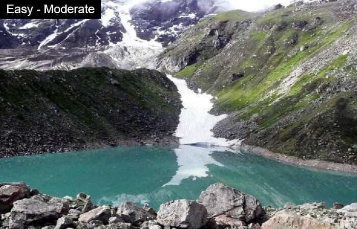
Gokyo Lake 1 is around 2 hours 40 minutes out of Macchermo. Behind the Gokyo settlements, you can see Cho Oyo dominate the background like a white wall. To the left of the settlement is the trail to Gokyo Ri at 17,575 ft. You get one of the best views of Everest range from here.
Time taken: 6 hours to Gokyo Ri and back; 3 hours to reach Thangna
Steep ascent to Gokyo Ri. To Thangna, short steep ascent followed by 1.5 hours glacier walk. Gradual ascent after this.
Water sources: Start with carrying 2 litres of water. You can refill your water bottles at tea houses on the way.
Start the day by climbing Gokyo Ri. Though the mountain looks small, it will take 2-3 hours for you to reach the summit. From here, you will see the longest glacier in the Himalayas – Ngozumpa – flowing down, and the big mountains in front. You’ll also get a beautiful view of the Gokyo lakes behind you.Don’t forget to get photographed with Everest!
After an early lunch, head out to Ngozumpa glacier. You need to cross over this to get to Thangna, at the base of Chola Pass. Ngozumpa glacier is an unstable section of the trek that is prone to rockfalls so make sure you follow your guides. This is a beautiful glacier which is moving constantly, but you don’t feel the movement.
You’ll take an hour and a half to cross the glacier. Thangna is a mostly flat walk from here.
Thangna is located at the foot of the Cho-La pass at an altitude of 15,580 ft. This is your rest day.
Time taken: 9-10 hours
4-5 km gradual ascent followed by 1 km of gradual descent. 1-1.5 km of trekking on boulders followed by 1 km glacier walk. 1 km steep descent on boulders easing off into a gradual descent.
Water sources: Start with carrying at least 2 litres of water. No water sources till you cross Cho-la pass.
Cho la Pass is right behind Thangna. The ascent, which is quite a climb, has a lot of rubble and scree. The descent is tricky with a snowed out glacier and boulders. Stick to the right of the glacier and follow the guide strictly. Don’t venture on your own. Depending on the situation of the ice, crampons will be used.
After the boulder patch which is hard on your knees, it is a steep descent to Dzongla. You’ll see Ama Dablam’s front view on this day. What a different side to this beautiful mountain!
Time taken- 3 hours
Water sources: Carry 2 litres of water..
The 3 hour walk to Labouche is mostly on a flat trail but you will be walking at quite an altitude. You’ll come across a junction where the trail splits to Pheriche and Labouche. Take the left. Views of Ama Dablam will accompany you till this point.
Around 90 minutes before Labouche, you’ll meet trekkers going on the traditional Everest highway. Helicopter sorties are commonplace here.
Trek gradient: Moderate. Short, steep ascent followed by 1.5-2 hours of boulder walk. Ends with a gradually ascending trail.
Water sources: Carry sufficient water. You’ll find teahouses on the way to Gorakshep.
It takes about 3 hours to reach Gorakshep, which is a very busy place. You’ll see the terrain change as you approach the place. There are a lot of trekkers coming in. You’ll see Everest Base Camp on the trail to Gorakshep.
After early lunch at Gorakshep, set off for EBC. Make sure you carry your day pack since you’ll need water. The climb is fairly moderate, though the moraines are slippery and the ridge bordering Khumbu glacier is very windy. Everest Base Camp provides a very unique experience since you’ll see potential summiters. The climbers’ tents look striking against the backdrop.
Pease note: drinking water at Gorakshep is chargeable. 1 litre of drinking water costs 350 Nepalese rupees. This is not included in the trek fee. Non potable water is available free of cost – if you’re carrying a water purifying bottle, you could consider using that instead.
The other main highlight of the trek is side trip to Kala Patthar summit (5,644m). It almost takes 2-3 hours to reach Kala Patthar from Gorakshep. So, many trekkers kick off their trek before dawn. If clouds don’t roll down quickly then the summit offers the gleaming view of Mt. Everest (8848m) along with Lingtren (6,749m), Khumbutse (6,636m), Nuptse (7,861m), Pumori (7,161m). Capture the Himalayan range in your soul or camera and also Savor tantalizing panorama at the peak for a few hours before descending to Gorakshep. After breakfast at Gorakshep, the journey from the land of Himalayas descends the same route towards the Sherpa village Lobuche. Lobuche is a junction from where the trail follows the route of Dhugla village along tea houses, tombstones, Lobuche Kharkha. At Dhugla, the trail stops at a fork which leads to Dingboche or Perische. Following the route of Phulaji Kala village, stroll down towards the wide valley, Perische. The village is famous for the elementary health camp that is run under Himalayan Rescue Association (HRA). The health camp provides emergency health service and education about AMS to the trekkers. Today, we sojourn at Perische.
Trek Distance: 9.6 km/6 miles
Trek Duration: 5-6 hrs
Highest Altitude: 5,545m/18192ft
We’ll be trekking down the trails of the hillside covered by rhododendron trees towards Tengboche. During spring, the surroundings would be so colorful as magic in nature. Our trek will cross the bridge over the Imja Khola and heads into the forest of Juniper. As we walk along with a level of the path of ground through the forest The trail continuously drops down to Orso via a flat trail following the west bank of Imja river and then to Somare. Again, the trail drops down to Pangboche along imja khola and climbs up to Debuche and Tengboche through dense forest.
Trek Distance: 8.5 km, 5.2 miles
Trek Duration: 4-5 hrs
Highest Altitude: 4,371m/14,340ft
After having a refreshing breakfast, today’s trip descends from Tengboche to the most commercial hub, Namche. From Tengboche, descend to Phunki Thenga and again ascend to Sanasa following the same route. The trail presents a relaxing sight of picturesque landscape and mountains while climbing the ridge to Namche. Yippee! The tourist epicenter, Namche is a perfect place to celebrate your achievement. Have fun with international cuisine and chilled beverages at your lodge or at restaurants in the evening.
Trek Distance: 9.2 km/5.7 miles
Trek Duration: 5-6 hrs
Highest Altitude: 3,860m/12,633ft
After breakfast at Namche, Like the other normal days the trek resumes down the steep path to Lukla crossing Dudh Koshi river and Suspension bridge. The small Gompas, rhododendron forest, pleasant environment en-route bewitch the trekkers. Hence, walking for a few hours from Namche, the dense village in the Himalayan region, Lukla appears fascinating from a distance. Lukla is the village with all modern amenities. Enjoy happy hour at Lukla by playing billiards, exploring the pubs or sipping beverages. Overnight, stay at an accommodated lodge in Lukla.
Trek Distance: 13.6 km/8.2 miles
Trek Duration: 6-7 hrs
Highest Altitude: 3,440m/11,285ft
The EBC trek concludes after a 30-40 minutes scenic flight from Lukla to Kathmandu. Shift your seat to the opposing direction than your previous flight for the overall view of a daunting landscape. After landing at TIA, you will be transferred to your respective hotels. Your adventure in Nepal comes to an end today! There is nothing to do but trade emails with your travel companions and organize your photos. A representative from our company will take you to the airport, approximately 3 hours before your scheduled flight. On your way home you’ll have plenty of time to plan your next adventure in the wonderful country of Nepal
Trekkers must reach Kathmandu on their own, a day or two before to avoid any last minute hassle. To reach Kathmandu from India, either book a flight from Delhi to Kathmandu or come through Bus/taxi service. Regular buses run from all major border areas to Kathmandu.
Note : if coming through India via Sunauli through Gorakhpur, you must exchange the currency at Border for the transit. Lots of currency exchanges are available at the border.
The cost of arrival and departure from Kathmandu is not included in the trek fees.
Our trek fees includes :
Our trek fees does not include :
Transit to and from Kathmandu.